Green energy
Published over 13 years ago. See the latest and most current information on Green energy.
Following warnings from the UK energy regulator Ofgem of an ‘horrendous’ energy crunch, aerial mapping company Bluesky (UK) is helping electricity companies ensure their power networks are resilient to the threats from falling trees and overgrown vegetation. Using Bluesky’s digital tree map data, known as ProximiTREE, agricultural and environmental consultancy ADAS has helped a number of utility companies prioritise vegetation management activities on overhead lines. This increases the resilience of the lines, therefore protecting customers from blackouts and improving cost and operational efficiencies for the operator.
“By helping electricity companies to identify at risk sections of the network and actively plan their vegetation management activities, we are shifting the approach from the usual ‘reactive’ emergency response to a tactic that is proactive and planned,” commented Alison Riding, Team Manager for Environmental Informatics at ADAS. “This has positive financial implications as the costs of achieving resilience are clearly delineated for each portion of the network, which also improves customer service and helps companies comply with newly introduced legislation.”
Using Bluesky’s ProximiTREE data, the Environmental Informatics team at ADAS is able to automatically analyse entire electricity networks. Advanced geospatial analysis is used to identify specific sections where tree pruning and cutting activities should be prioritised. Once the routes have been selected, the next stage is to carry out a robust arboricultural survey and ADAS has devised an innovative approach by assessing trees from an arboricultural point of view and incorporating a risk assessment of the tree falling across the line in severe weather conditions.
“It is well known that trees are one of the largest threats to our aging electricity infrastructure,” commented Rachel Tidmarsh, Managing Director of Bluesky International. “The Department of Energy and Climate Change has recognised this and expects all electricity distribution network operators to make 20 per cent of the overhead network resilient within the next 25 years. By working in partnership with ADAS we can help them achieve this.”
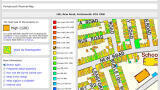
ProximiTREE is derived from the most accurate and up to date aerial photography. Using overlapping images the exact location of every tree can be mapped and the height and extent of its canopy derived. ProximiTREE is suitable for use in most desktop Geographical Information Systems (GIS), web mapping applications and Computer Aided Design (CAD) packages. Both 2D and 3D versions of the map are available and ProximiTREE works alongside existing Bluesky datasets such as 3D buildings, terrain models and aerial imagery.