Air clean up
Published over 6 years ago. See the latest and most current information on Air clean up.
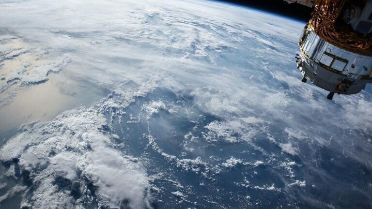
Researchers from Duke University in North Carolina, USA believe they have struck upon a novel method of monitoring pollution levels using satellite imaging and weather pattern data. While satellites have been used to quantify concentrations of particulate matter 2.5 (or PM2.5) for many years, there have been several drawbacks to the method’s functionality.
Current methods of satellite monitoring are prone to disruption from variable factors and incapable of producing accurate predictions on smaller scales. This means that while the satellites can detect that something is in the air, they are not proficient at determining exactly what or in what concentrations. The new technique, pioneered by Michael H Bergin and his student Tongshu Zheng, appears to be capable of overcoming both problems.
Satellite imaging has been used to estimate pollution levels for decades, by measuring the amount of sunlight that is reflected back into space by ambient particles of PM2.5. However, this method is unreliable when a whole host of variables are taken into account, including the presence of cloud cover, the differing properties of the particles in question and the fallout from atmospheric mixing.
While ground-based particulate matter sensing networks can provide corroborating evidence that can contribute to a more comprehensive overview of the state of play, they suffer from their own disadvantages which make the approach a less than ideal one. To top things off, ground-based PM monitors are few and far between, located only in certain countries around the world.
Keen to improve upon that inadequate system, Bergin and Zheng consulted Planet, an American company that has been using micro-satellites to take daily pictures of the Earth at high resolution. After obtaining photographs of Beijing from space every day for the last three years, the team then drafted in the help of David Carlson, an engineering professor at Duke and an expert in artificial intelligence.
Carlson was able to apply a sophisticated algorithm to the photographs, utilising weather data collected by Beijing’s main weather station. By factoring in such variables as wind direction, relative humidity and ambient temperature, the team were able to gain a more accurate picture of how heavily PM2.5 had been polluting Beijing’s airways.
In order to test the efficacy of their new approach, Bergin, Zheng et al undertook a study, now published in the journal Science Direct. First, they fed 10,400 images into their computer model and supplied it with corresponding weather data and actual PM2.5 concentrations collected on the ground, in order to train it. Then, they tested out how accurate it could be with its predictions on a further 2,622 images.
The results were impressive. The model was capable of predicting PM2.5 concentrations to within a 24% degree of accuracy, with is at the upper end for these kinds of simulations. What’s more, the improved model is also able to achieve that kind of accuracy on a much smaller scale than was previously possible. For example, existing standard practices normally predict concentrations at around 1 million square metres, whereas the new model could do so to a scale of 40,000 square metres. As such, it represents a huge step forward in our ability to quantify PM2.5 pollution via satellite alone.


_shutterstock_2296088597.jpg)