Air Monitoring
An instrument for sampling volcanic plumes from a UAV
Feb 12 2023
Author: Dr Dan Peters, Scientist at RAL space on behalf of Unassigned Independent Article
Volcanic ash poses a threat on a range of scales, ranging from ashfall in local communities to regional risks to aviation. Volcanic gases pose a further threat to the surrounding area, stemming largely from emissions of sulphur dioxide. For example, “vog” – volcanic smog – is a recurring issue in Hawaii, formed as volcanic SO2 interacts with the surrounding atmosphere to produce sulphuric acid aerosols.
Small eruptions of the kind common at volcanoes such as Stromboli (Italy) and Kilauea (Hawaii) produce plumes reaching up to hundreds of metres in the atmosphere, which drift in the direction of the prevailing wind [Figure 1]. Whilst plume dispersion models can predict the direction of travel of plumes, local measurements are needed to constrain the volume of pollutants present and verify the predictions of models.
Although many active volcanoes have established monitoring networks, a network of ground-based sensors is unlikely to be sufficiently dense to fully monitor the development of a moving plume; and monitoring networks may not be present at all around newly active volcanoes. Additionally, it is desirable to be able to measure pollutants at altitude within the plume and along its dispersal axis, as these may later affect communities further downwind.
UAV-mounted sensors provide a flexible, mobile solution to track plumes as they travel nearby populated areas. A collaboration between Dr Jean-François Smekens from the University of Oxford Department of Earth Sciences, Dr Cunjia Liu from Loughborough University and STFC worked to develop a new sensor package that can be deployed rapidly in response to a developing volcanic crisis, and provide the capability to validate models of plume dispersal and improve forecasts to protect local communities.
STFC RAL Space operates several UAV platforms, including fixed wing, multirotor, and a vertical take-off and landing UAV. The STFC UAVs are operated by the RAL Space Radiometry group who have three qualified pilots and CAA approval for commercial operations. With the expertise that has been developed in RAL Space there now exists an opportunity to operate the STFC UAVs for the wider academic and industrial community in a scientific context, including in the development of this package. RAL Space also have the expertise in miniaturisation of instrumentation to fit within the mass and power constraints of the UAV platform.
Sampling from turbulent airflows introduces biases to particulate measurements - a particular concern on multirotor UAVs. For this project a push prop fixed wing platform was chosen to ensure clean air flow around the UAV. To tackle the problem of turbulence induced by the body of the UAV the sampling inlet is extended in front of the UAV [Figure 4].
STFC Scientific Computing Department supported the project via Computational Fluid Dynamics (CFD) modelling. CFD models around a representative airframe were used to evaluate the best positioning of the aerosol sampling inlet with the aim of achieving isokinetic particle sampling. [Figure 2].
The instrument package developed consists of gas sensors in addition to an aerosol optical particle counter to provide the aerosol size distribution [Figure 3]. The gas sensor package consists of an NDIR CO2 sensor and electrochemical SO2 and H2S sensors.
The aerosol sensor inlet is connected to an isokinetic sampling probe, optimised to minimise aerosol loss at the UAV cruise velocity. The sensor package is sufficiently flexible that it can be extended with other gas sensors depending on the application needs and UAV payload capacity. Example results from the instrument package are shown in [Figure 5], demonstrating the response of the sensor to events in a domestic environment.
Sensor data is measured in real time by a microcontroller and data logged via a microcomputer. Provision is made to send live data to monitor instrument responses during plume sampling. The full data logs are recorded to an SD card as a time stamped data stream for offline analysis.
Using a fixed wing UAV permits flight times of up to 90 minutes, allowing complex flight patterns and the ability to track the development of plumes over time. A long flight also enables surveying of air quality over larger areas than would be possible with conventional ground-based sensors. The flight pattern can also be tailored to fit with the instrument sampling, for example by holding a suitable pattern to integrate measurements over time at a particular location. It should however be noted that the flight capabilities depend on the local rules, and in the UK this is regulated by the UK Civil Aviation Authority, and is generally limited to visual line of sight without special approval.
An example of another application of the instrument package is measurements of air pollution in UK ports. On the 1st of January 2020 a major change occurred in the legal sulphur content of shipping fuel – from 3.5% to 0.5% by mass. The anticipated effect of the new regulation is improvement of coastal air quality and, since Sulphur is believed to be a negative climate forcer, a potential positive influence on climate. The instrument package has been tested for identifying ship emissions in collaboration lead by Prof James Lee at the University of York. The inclusion of the CO2 sensor facilitates direct measurements of ship emissions by emission ratios to the other species, demonstrating the versatility of the instrument.
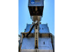
Figure 4. E384 payload bay with instrument.
Conclusions
Our ambition for this instrument is to not only provide a direct measure of air quality over local communities, but also help validate models of plume dispersion, which are used for forecasts and mitigation during volcanic eruptions.
Work done to reduce sampling inlet bias is applicable to any project involving particulate sampling with a UAV and could form a starting point for future projects with STFC UAVs. Future work includes investigating further application areas and test flights of the UAV with the sensor package.
This work has been funded via the STFC Air quality network (https://www.saqn.org/) during the scoping study “A UAV-ready sensor package for rapid deployment during volcanic crisis” and the proof of concept study “Enabling the remote measurement of air pollution emissions in UK ports”.


Events
Apr 22 2024 Hannover, Germany
Apr 23 2024 Kuala Lumpur, Malaysia
Apr 24 2024 Sao Paulo, Brasil
May 05 2024 Seville, Spain
May 13 2024 Munich, Germany