Water/Wastewater
MWH Treatment Embraces 3D Mapping to Elevate Water Project Planning
Sep 29 2023
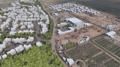
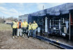
MWH Treatment is harnessing the power of highly intricate, geographically precise 3D models to revolutionise the planning of water projects. These models, provided by the pioneering aerial mapping company, Bluesky, offer a tangible visual representation that faithfully captures and records existing assets and features in their precise geographical context.
These cutting-edge Bluesky models are driving efficiency and enhancing collaborative efforts within MWH Treatment. Moreover, they can be customised to incorporate new design and survey data, already finding their place in several of MWH's live projects spanning six Water Frameworks.
Stephen Peters, Senior Engineering Technologist at MWH Treatment, underscores the significance of these Bluesky models, stating, "The Bluesky models furnish our project teams with invaluable location and contextual information. They form the bedrock of our visualisations, enabling us to deliver safe, sustainable, and high-quality solutions to our clients."
MWH Treatment, a distinguished provider of water solutions with a 200-year legacy, adapts Bluesky's models for utilisation in various software packages, catering to collaborative planning, engineering, and even gaming. These models establish the project's backdrop, providing a contextual canvas for animations and interactive applications, streamlining the creation of site elements like trees, buildings, and roads while reducing manual resource allocation. Additionally, elements within the models can be altered to incorporate fresh design and survey inputs.
Clare Taylor, National Rehearsal Lead at MWH Treatment and Chair of BIM4Water, emphasises the models' critical role in risk assessment: "Having a comprehensive overview of the surrounding area is indispensable for identifying potential project risks, from logistical concerns to neighbouring properties or businesses. Equally, it allows us to spotlight and minimise the project's impact on our clients and their customers. The Bluesky models' final outputs are seamlessly integrated into our digital tools, optimising workflows and engaging engineering and construction teams, as well as our clients, at pivotal stages. This fosters efficiency and encourages safe, collaborative work practices."
Ralph Coleman, Chief Commercial Officer at Bluesky, notes, "Derived from stereoscopic aerial photography through photogrammetry, our 3D models are provided in wireframe or solid surface formats, compatible with both CAD and GIS software. This versatility makes them accessible to a wide array of users. The surge in integrated 3D application development has propelled the adoption of 3D modeling in geospatial contexts, empowering professionals across various sectors to harness the capabilities of 3D workspaces. It's fascinating to witness the application of our data in projects like those undertaken by MWH."
All Bluesky 3D models are bundled with a Digital Terrain Model (DTM) that faithfully represents the underlying surface's topography.
Clare Taylor concludes, "The process of requesting and obtaining data from Bluesky is swift and uncomplicated. With data derived from the latest, most accurate aerial photography, we have unwavering confidence in the currency and positional accuracy of the resulting outputs."


Events
May 05 2024 Seville, Spain
May 13 2024 Munich, Germany
May 23 2024 Beijing, China
May 23 2024 Beijing, China
Jun 10 2024 Algiers, Algeria